SatMap
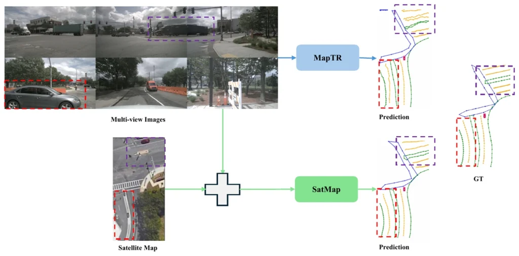
Cameras alone lose lane geometry behind parked cars and buses. SatMap aligns a satellite image of the same place to the ego pose and fuses it with the multi-view camera features, so the map decoder can complete what the cameras cannot see.
What it does
Satellite tiles give lane-level semantics and texture from a bird’s-eye view — exactly the geometry that a forward-facing camera has to guess. The tiles are aligned to the ego pose, encoded into BEV and fused with the camera BEV features; a vectorised decoder then predicts polylines for lane dividers, boundaries and crossings, ready for prediction and planning downstream.
Abstract
Online high-definition (HD) map construction is an essential part of a safe and robust end-to-end autonomous driving (AD) pipeline. Onboard camera-based approaches suffer from limited depth perception and degraded accuracy due to occlusion. In this work, we propose SatMap, an online vectorized HD map estimation method that integrates satellite maps with multi-view camera observations and directly predicts a vectorized HD map for downstream prediction and planning modules. Our method leverages lane-level semantics and texture from satellite imagery captured from a Bird’s Eye View (BEV) perspective as a global prior, effectively mitigating depth ambiguity and occlusion. In our experiments on the nuScenes dataset, SatMap achieves 34.8% mAP performance improvement over the camera-only baseline and 8.5% mAP improvement over the camera-LiDAR fusion baseline. Moreover, we evaluate our model in long-range and adverse weather conditions to demonstrate the advantages of using a satellite prior map. Source code will be available at https://iv.ee.hm.edu/satmap/.
Result
Citation
@inproceedings{Mazumder2026SatMap,
title = {SatMap: Revisiting Satellite Maps as Prior for Online HD Map Construction},
author = {Kanak Mazumder and Fabian B. Flohr},
url = {https://arxiv.org/abs/2601.10512},
year  = {2026},
date = {2026-01-01},
urldate = {2026-01-01},
booktitle = {International Conference on Pattern Recognition (ICPR)},
publisher = {IEEE},
keywords = {},
pubstate = {published},
tppubtype = {inproceedings}
}